
The mountain above Ebbw Vale Festival Park is not only a beautiful place to walk, but is rich with evidence of its industrial past.
Cefn Manmoel is the name given to the broad ridge of high ground between the Sirhowy Valley and Ebbw Vale in the Valleys region of South Wales. It straddles the boundary between the unitary areas of Caerphilly and Blaenau Gwent.
The NNW-SSE aligned ridge achieves a height of 504m at OS grid ref SO 166072. To the south it drops away to a broad saddle southeast of the village of Manmoel, beyond which lies Mynydd Pen-y-fan.
Parts of both its eastern and western flanks are afforested with conifer plantations such as at Coed y Rhyd and at Coed y Llanerch.
There are numerous abandoned quarries on the steep flanks of the ridge.
Significant parts of the hill are moorland and have been mapped as open
country under the CRoW Act** thus giving a right of access to walkers. Similar
rights apply to some of the afforested areas. There are a number of public
footpaths and other public rights of way over the
hill. The Sirhowy Valley Ridgeway Walk and the Ebbw
Valley Walk follow some of these routes.[
 OS Classification
Cefn Manmoel is the name given to the broad ridge of high ground between the Sirhowy Valley and Ebbw Vale in the Valleys region of South Wales. It straddles the boundary between the unitary areas of Caerphilly and Blaenau Gwent.
The NNW-SSE aligned ridge achieves a height of 504m at OS grid ref SO 166072. To the south it drops away to a broad saddle southeast of the village of Manmoel, beyond which lies Mynydd Pen-y-fan.
Parts of both its eastern and western flanks are afforested with conifer plantations such as at Coed y Rhyd and at Coed y Llanerch.
 |
| Winding wheel from Engine House Domen Fawr |
The entire hill is composed of sandstones and mudstones dating from the Carboniferous Period. There are also numerous coal seams
within the sequence, most of which have been worked. The upper part of the hill
including the summit plateau is formed from the Pennant
Sandstone, a rock assigned to the Carboniferous Upper
Coal Measures.[1]
The flanks of the hill owe their steepness in part to the action of glacial ice
during the succession of ice ages.
Walking from Cefn *Manmoel to the Domen Fawr the
defensive hedge dating back to the Dark Ages is evident, (ninth or tenth century). The ridge
and furrow fields dating back to the 18th or 19th century are also visible, along with the burial cairns
from the Bronze Age on top of the Domen Fawr. From the Domen there are wide views along the length of the valley, with a clear sight of the
old steel works site.
 OS Classification
Mountain or large hill
OS Grid Reference
 |
| Rusting boiler in remains of Engine House on slopes of Domen Fawr |
SO1607 (316500, 207500)
WGS84 Coordinates
51.7595, -3.20997
County Council (Unitary)
County Council (Unitary)
Blaenau Gwent Council
Parish
http://en.wikipedia.org/wiki/Cefn_Manmoel
Parish
Ebbw Vale South Community
Parliamentary Constituency
Parliamentary Constituency
Blaenau Gwent
*Manmoel translated from Welsh means "bare place."
http://www.housenameheritage.com/hnh_wsc_welsh.asp
 |
| The old tramroad |
 |
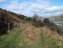
| View from Domen Fawr |
*Manmoel translated from Welsh means "bare place."
http://www.housenameheritage.com/hnh_wsc_welsh.asp
http://en.wikipedia.org/wiki/Cefn_Manmoel
**Countryside and Rights of Way Act
2000
The Countryside and Rights of Way Act 2000 (sometimes called the CRoW Act) is a UK Act of Parliament affecting England and Wales which came into force on 30 November 2000.
The Act implements the so-called 'Right to Roam' (also known as jus spatiendi) long sought by the Ramblers' Association and its predecessors, on certain upland and uncultivated areas of England and Wales.
http://www.legislation.gov.uk/ukpga/2000/37 to view Countryside and Rights of Way Act 2000.
No comments:
Post a Comment